Start with the people, the yacht and the whole route
Before departure, I check conditions along the planned passage and at the harbour I intend to enter. Even a short training outing needs a return plan: a change in wind direction can make berthing harder, and heavy rain can reduce visibility.
Conditions that are manageable for an experienced crew on a well-equipped yacht may be too demanding for a first lesson. Consider the crew's preparation, equipment, sea state, available shelter and difficulty of the approach. Leave time for manoeuvres and an earlier return.
Select a forecast for the right sea area, date and hours. A city-centre or airport point may not represent the marina entrance. Check whether times are local or UTC, and compare forecasts using the same time basis.
What to check before leaving
| Parameter | Practical question |
|---|---|
| Wind and gusts | What is the sustained wind, and how strong could brief gusts become? |
| Wind direction | How will it affect the route, shelter, harbour approach and berthing? |
| Waves and swell | What are the height, period and direction, and how will they affect the yacht? |
| Rain and thunderstorms | Are active cells or a rain band approaching the route or return harbour? |
| Visibility and daylight | Will the approach be suitable for this crew when we arrive? |
| Official warnings | Which area and time period are covered, and what does the text predict? |
| Tides and currents, where relevant | How will they affect progress, depth, sea state and entry timing? |
Sustained wind and gusts are different values. The size of a gust above the background wind can matter when manoeuvring. Check the parameter, averaging convention where available, and units before comparing apps.
One knot equals 1.852 km/h. For example, 20 knots is about 37 km/h and 24 knots about 44 km/h. These are conversions, not universal safe limits. Set suitable limits for the particular crew, yacht and location, with a margin for uncertainty.
Wind direction normally describes where the wind comes from. Read the legend for wave and current displays instead of assuming that every arrow uses the same convention. Wave height alone also needs context: period, direction and steepness affect comfort and control.
Radar, satellite and forecast are different kinds of information
A weather app may combine several sources on a single map. Rain radar displays observed precipitation where radar coverage exists. Satellite imagery shows clouds over a broader area. Future frames show predicted conditions, even if they look like the observed frames beside them.
A layer labelled “WindRadar” is a graphical display of wind information; it does not make future gust values a direct measurement at your yacht. Read the layer description, timestamp and coverage information. A blank patch can mean missing data rather than clear weather.
Recent radar movement can help you assess the next part of an outing, but cells may grow, weaken or change direction. A longer forecast needs more than moving the current picture across the map. Clouds at altitude also do not tell you directly which way the surface wind is blowing.
Use the map and time slider deliberately
- Find your sailing area and keep the route and return harbour in view.
- Zoom out to see the weather approaching from outside your local area.
- Play recent observed frames and note whether rain is moving, developing or fading.
- Check the timestamp of the latest data; “now” may still include a delay.
- Move into the forecast period and compare departure, the middle of the outing and the return.
- Pause to read the time, units and colour legend.
- Inspect wind, gusts, waves, clouds, precipitation and lightning separately.
In Weather & Radar, use the time controls and the legend or information panel available in your version. The interface can change. Advancing the slider into the future means looking at a forecast.
On tidal coasts, compare the weather window with the current and access window. Wind against tide can make a passage more demanding even when the wind speed itself changes little.
A small toolkit of useful sources
Use maps for spatial awareness, point forecasts for timing, and the responsible national service for official warnings. Open the services below and search for your actual sailing area.
For another country, find its official meteorological service, marine forecast and relevant coastal warnings. If language is a barrier, obtain a reliable interpretation of the warning text before making a decision.
Yr's radar-based short-term precipitation product has regional coverage, including Nordic areas; do not assume the same observation-based product is available in Croatia. Service features and coverage may change, so check the current description.
Why forecasts disagree
First make sure you are comparing the same location, hour, parameter and units. Then check the model and update time. Two apps using the same model are not two independent forecasts. Different models may handle local terrain, coastlines and timing differently.
A disagreement is useful information about uncertainty. Leave more room in the plan, consider a shorter passage and keep a workable alternative. Do not automatically choose the most favourable forecast.
An airport observation can provide context, but METAR and TAF are aviation products for a different location and purpose. Use marine forecasts and local observations for the sea and harbour approach.
Thunderclouds are a reason to reassess early
Cumulonimbus clouds develop strongly upwards and are associated with thunderstorms. They may have a dark base and an extensive upper part, sometimes spreading into an anvil. Associated hazards can include heavy rain, hail, lightning and sudden gusts.
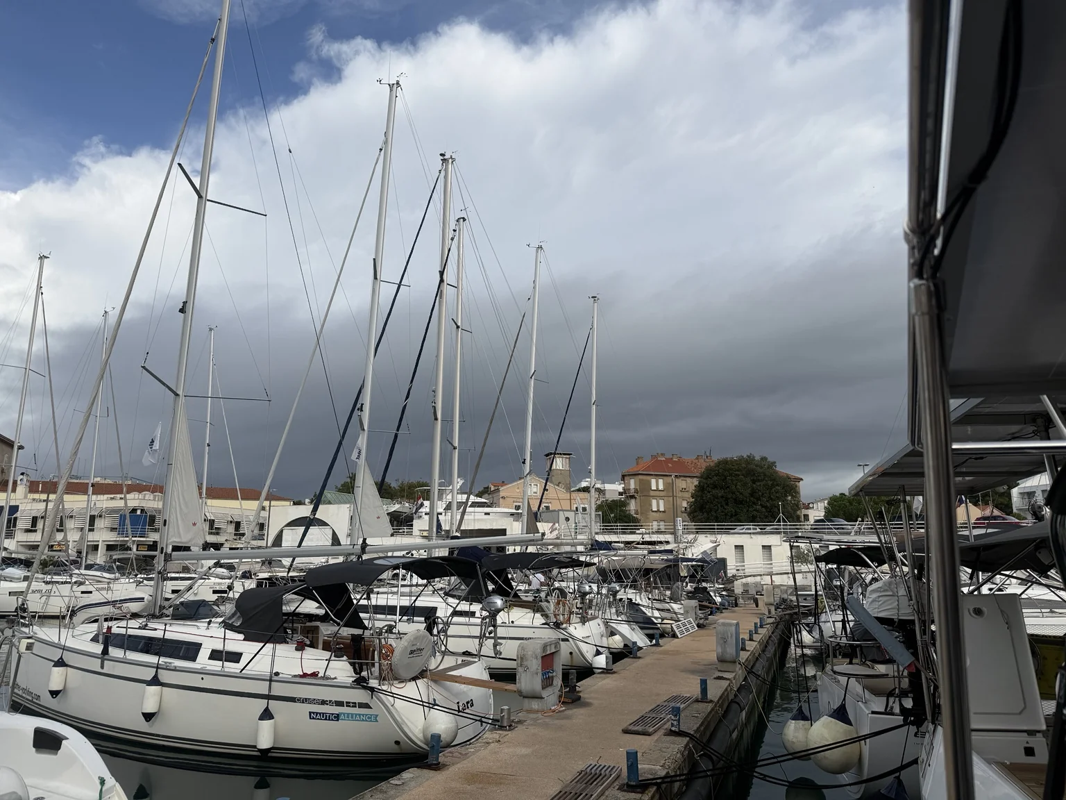
The Zadar photograph shows extensive cloud with a bright upper part and darker base. It does not show enough of the complete cloud to establish its type and development stage with certainty. A view like this is a reason to check the sky's development, radar, lightning data and warnings.
If you can hear thunder, lightning may already be close enough to present a danger. Do not wait for rain to reach the yacht before acting. With a storm approaching, I postpone a training departure where staying in shelter is the safer choice.
If already afloat, assess the route to a suitable safe place and prepare the yacht and crew early. Rushing into a difficult harbour at the strongest part of a squall may introduce another hazard. Avoid assuming that a particular distance from a storm or an empty lightning map guarantees safety.
Find a window that covers the whole outing
A quieter hour is useful only if it allows the whole planned activity. For a short trip from a marina, check leaving the berth, sailing and returning. Add time for preparation, delays, possible fuelling and berthing.
Imagine that wind remains similar for several hours, but the afternoon forecast shows rain moving across a channel and the return port. An earlier, shorter outing may be a better plan. If observations show the storm moving faster or gusts becoming stronger than expected, reassess immediately, including the option to remain in port.
On the Adriatic, consider conditions around islands, in channels and at the marina entrance. On the Baltic, a longer exposed leg may have fewer easy shelter options. A wind shift can change which berth or anchorage is protected.
Keep reassessing when the sky, wind, route or crew condition changes. Save useful forecasts and warning text before departure if internet access may be lost, and plan how to obtain updates by marine radio where available. A saved screenshot retains its original issue and validity times; it does not become current because it is still on your phone.
Frequently asked questions
Is one app enough?
It can be a convenient starting point. I combine it with official warnings, an appropriate marine forecast and observations. When sources disagree, I check their model, timing and coverage.
Does an empty rain radar mean there is no danger?
No. Check whether current radar data exist for that location, then assess wind, gusts, waves, visibility and warnings as well.
Does green on a wind map mean safe sailing?
A colour represents a range in the legend. Suitability depends on the crew, yacht, direction and location. Read the point values and leave a margin, especially near an agreed limit.
Quick checklist
Use this short reminder alongside the full guide. Adapt it to the yacht, sailing area and crew.
Sources and further reading
- Polish original — opens in a new tab
- Met Office: global map data and layers — opens in a new tab
- Met Office: nowcasting — opens in a new tab
- Weather & Radar: live and forecast map frames — opens in a new tab
- Yr: how forecasts are made — opens in a new tab
- Met Office: low-level clouds, including cumulonimbus — opens in a new tab
- Met Office: thunder and lightning safety — opens in a new tab
- DHMZ: official Croatian warnings — opens in a new tab
Sources checked 11 October 2026.